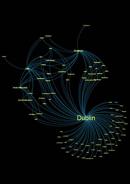
The image above is a network chart of flights out of Ireland as operated by Ryanair from the following airports:
- Cork;
- Dublin;
- Kerry;
- Knock Ireland West; and
- Shannon.
The data is not organised geographically, but in terms of connections between nodes. The nodes on the charge are various airports, and the links, or edges are operated routes. This chart shows all the connections between the five Irish airports above and any airport that Ryanair flies to from those airports.
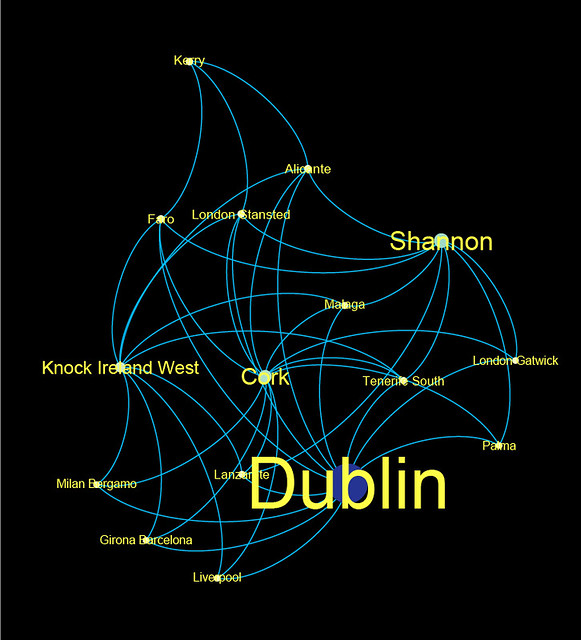
However, Gephi allows you to fine tune what you want to see, and so there is this:
This basically includes only those nodes which have three connections to other nodes. So only those airports which are destinations for at least 3 other nodes in this network. If you like, it basically includes destinations which are served by Ryanair from at least three airports in Ireland. Without looking in too much detail, you could probably guess a few: London Stansted is an obvious candidate. Dublin still has the most connections; this is not surprising as it had 80 or so to begin with. But the target airports are interesting:
- Alicante;
- Faro;
- London Stansted;
- Malaga;
- Tenerife South;
- London Gatwick;
- Palma;
- Lanzarote;
- Milan Bergamo;
- Girona Barcelona; and
- Liverpool.
Most of those airports, with the exceptions of London Gatwick and Stansted, and Liverpool, are holiday destinations. The outlier – as in the one I did not really expect to see – was Milan Bergamo.
The graph would probably be bigger if I stripped it down to airports with two connnections, mainly because Dublin has destinations in common with most of the other airports. Fuerteventura is one of the few destinations which is served by Cork and Shannon but not by Dublin, for example.
Gephi is a really nice tool to use for stuff like this and I have other plans for it. This is actually the first project I have done using it and I have an interest in figuring out how much more I can customise to use more data. For example, there is no weighting on any of the edges in either of the graphs above, and that parameter could probably be used to demonstrate frequency or seasonality. I have other plans as well. I also have plans to do something like this with bus routes in Dublin and general public transport, for example.
Couple of notes about the data:
- Route data was collected on 12 May 2015. As such, it will go out of date as Ryanair update their routes out of Ireland.
- It does not take account of any seasonal differences: all of these flights may not operate year round. Personally am considering a flight to Grenoble myself as I did not know one existed until today.
- This is a proof of concept for other work I want to do later with transport routing.
- I will probably look at other airlines later if I can access the data easily.


One thought on “Flight routes from Ireland operated by Ryanair”
Comments are closed.