I wrote a piece over on windsandbreezes on that New York Times piece on Amazon’s HR evaluation practices. I was going to do another version of it for here but I am actually a bit too busy so here’s a pointer to roughly what I am thinking about it.
Month: August 2015
CMD-window Space invaders written in Go
Stuff like this, I feel, is why technology should exist and not, for example, automatic face recognition on remote cameras.
Implementation of Space Invaders written in Go. Kudos to Asib.
GIT and open source, the victory or not
During the week, Wired published a piece under the title Github’s Top Coding Languages Show Open Source Has Won.
This is basically – and I am being diplomatic here – not what Github’s Top Coding Languages shows.
Fundamentally, for Github to show this, every piece of operational code would have to be on Github. It isn’t. I’d be willing to bet less than half of it is, and probably less than a quarter, but that’s a finger in the air guess. Most companies don’t have their code on Github.
What Github’s top ten coding language shows is that these are the ten most popular languages posted by people who use Github. Nothing more and nothing less.
I suspect Github know this. I really wonder why Wired does not.
National bus stops
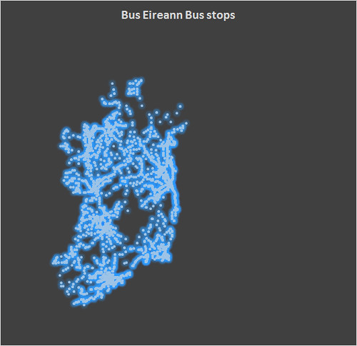
Having done Dublin Bus, it occurred to me to see if the Bus Eireann network was available. It is.
This is actually a bit more interesting than the Dublin Bus one for various reasons, specifically the gaps. I’m fascinated by the big hole in the middle and I will probably look at doing some additional work in terms of other spatial data.
I’ve just been asked where I get the data and it’s remiss of me not to credit the data source. The data for both Bus Eireann and Dublin Bus, plus a number of other operators is available on Transport for Ireland’s website. The link is here.
I haven’t cleaned up this graph all that much and I have additional plans for this and the other transport data that I have been looking at.
The beauty in Dublin Bus Stops
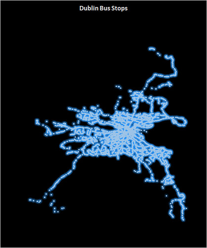
I have an ongoing project in the area of public transport in Dublin, which has a) stagnated for a while and b) grown a bit since I have had to interact more with public transport in Dublin.
This is one of the items on the project list. This image is a scatter plot of Dublin Bus latitude/longitude values for Dublin bus stops. The file this is based on, which I pulled into Excel to do this (yes, I have other plans involving R at some point which may see this revisited) has more than 4700 datapoints. Looking at it like this, I’m going to see if I can find a similar dataset for street lights. I think it’s a rather beautiful looking spiders’ web.

